We’re on our way north to Southeast AK! This blog is a word-for-word repeat of the Facebook posts that we have been putting up daily as we cruise north. We’re posting here for the non-FB users. Click on the Youtube links for animations of our travels.
Day 1
We left Seattle around 10:00 am, had a quick transit through the locks, and headed to Port Townsend. We had a intermittent problem with one of our generators, which finally crashed on Sunday (the day before Memorial Day. I picked up new raw water pump first thing Tuesday morning, and we headed out. This was probably the world’s slowest one day delivery service. We arrived at Port Townsend around 3 in the afternoon, and the new pump was installed by 5. We left Port Townsend and crossed the Strait of Juan de Fuca. The seas were very calm, and we made good time in the crossing. We arrived at Watmough Bay on Lopez Island just as the sun was setting. Dinner was linguine with pasta sauce and mushrooms. Tomorrow morning we will get underway early and head for Canada to begin the long trek north. Here’s a link to the trip animation.
https://youtube.com/shorts/vTxLKtZLejQ?feature=share
Day 2
Today was a long day, for a number of reasons. When planning a trip north, the number one factor is tides as nd currents through narrow passages. The other number one factor is weather – mainly wind and waves. Fortunately we have a lot of resources to help, ranging from printed books (Waggoners guide) which describe all the major harbors along the way, to GPS enabled marine apps (Garmin, Furuno) which let us plot a course and tells us how long it will take to reach a point at our current speed. The Garmin app also has crowdsourcing – lots of comments by other boaters about various anchorages. For weather we use PredictWind which does a pretty good job of predicting wind strength and direction over the next few days.
Today we left Watmough Bay at 6:45 am, and cruised through the San Juan islands. By 11:30, we were at Bedwell Harbour on N. Pender Island where we cleared Canadian customs. At that point we thought we would spend the night somewhere in the Gulf Islands. But then we realized that we could make it to Prolier Pass at slack water. (We have books with all the tides and currents from Seattle to Alaska every day of the year). Slack is very important to us. Since the water often races through the passes faster than we can go in the Gyrfalcon- so we always aim for close to slack.
Anyway, we exited the Gulf Islands through Porlier Pass, and headed north into the Strait of Georgia. Then we started to consider an anchorage for the night. The wind was projected to be 6-8 knots through the night, and blowing from the northwest. There are not a lot of anchorages on this bit of the BC coast. Several of them opened to the northwest, which meant a potentially uncomfortable night, so they were out. Boho Bay off Lasqueti Island is more protected, and we could reach it before the sun set, so that one looked good. The only problem was Whiskey Golf – a large area where the Canadian Navy shoots torpedos and other arms. If Whiskey Golf is active, you can’t cross it – which would add hours to our journey. Fortunately, it was not active today, so we cut across and reached Boho Bay just before sunset. The trip across was a bit sporty – a lot of spray over the bow, with 1-2 waves and 10-20 knot winds ( more than predicted ). We are anchored now and the winds have dropped. Hopefully it will be a good night. Tomorrow we will transit the biggest narrow of British Columbia – Seymour Narrows. More on that tomorrow. Here’s the trip animation:
https://youtube.com/shorts/TgCnm7nQ4ug?feature=share
Day 3
Our goal was Seymour Narrows. In order to go north through British Columbia, you have to pass through one of several narrows – passages where large amounts of water come roaring through a steep channel. Seymour Narrows is the largest option, one that is used by most of the commercial traffic (tugs, cruise ships, etc.). There is a “back-door” option, but it involves several consecutive narrows and a lot of math and worrying, so we have almost always taken Seymour.
Seymour used to be a lot scarier, because there was a large rock (Ripple Rock) right in the middle of the narrowest part. In April, 1958, the Canadian government blew the top off the rock. It was the largest intentional non-nuclear explosion ever. I put a video link in the comments. It’s worth a watch.
The current through the narrows is determined by the moon (tidal). Since we are just about at full moon now, the maximum current is around 12 knots. Since we travel at around 7.5 knots – well I’ll let you do the math, but we would either be flying or traveling backwards, depending on the direction of the current.
So we aim for slack (no current, when the direction is changing). There is a short time on either side of slack when the current is under 2 knots. That is our window.
There is a slack today at 4:51 pm. We knew that the current would be against us in Discovery Passage going north to the narrows, so we added an extra hour to make sure we reached the Narrows before slack.
We left Boho Bay at 7:40 am. The Strait of Georgia was incredible. It can often be windy with confused waves, but today it was like glass. We made great time until we got to the southern end of Discovery Passage. All the water that comes through the Narrows rushes through Discovery Passage. Our speed dropped from 8 knots to under 4. We knew from past experience that there are back eddies along the shore of the passage, where the water goes against the current, so we were able to regain some speed. We got to the southern end of Seymour Narrows about an hour early, and joined several other boats waiting for slack. When the current dropped to 1.7 knots against us, we transited the Narrows. It was uneventful – the best type of passage.
Since it was already 5 pm, there weren’t a lot of anchorages we could reach before dark. North of the Narrows, the evening wind began to pick up. We headed for the Chained Islands, which give fair protection, and have good holding for the anchor. As we came around the corner, we could see that the waters inside the islands were calmer, and since we were the first boat in the harbor, we could anchor in the center with lots of room to swing. The wind is about 12 knots in the anchorage with gusts in the low 20s. Hopefully, the winds will calm down overnight. In any case, we are snug and secure for the night.
Here’s a link to a video about Ripple Rock and Seymour Narrows: https://youtu.be/bNjtXVzvVKo?si=v6PQdaXFQjSI1hPi
Here’s our trip animation: https://youtube.com/shorts/h7D1P5h5VXU?feature=share
Day 4
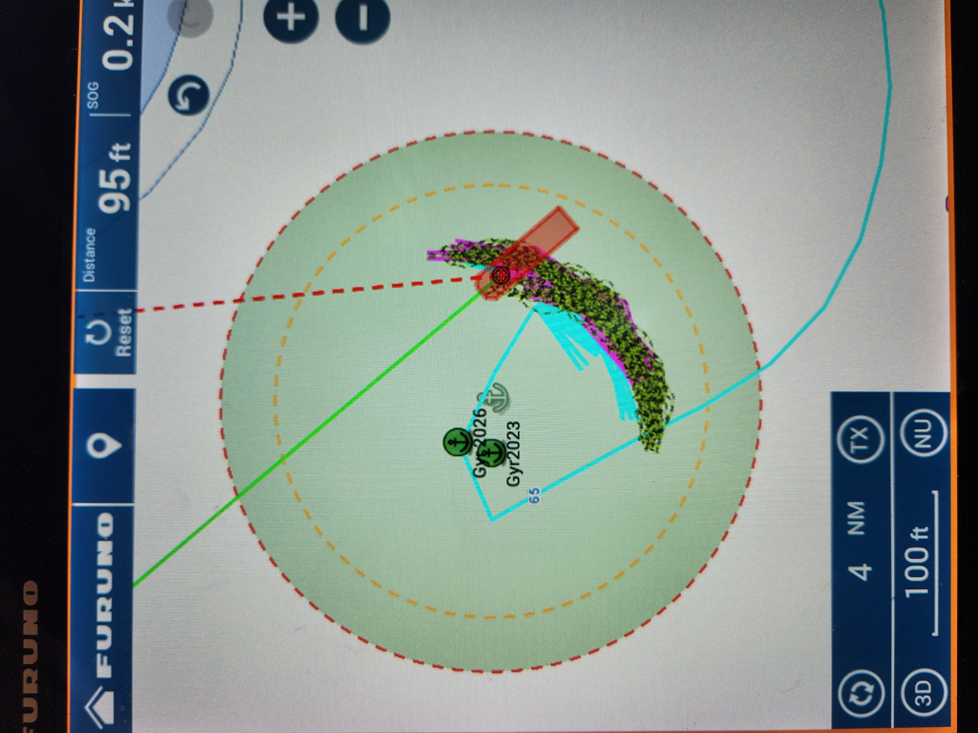
Several folks have commented on our trip animation (TravelBoast). You will probably notice that there is none for today. We didn’t go anywhere! The winds from last night continued throughout the day, with steady winds around 20 knots and gusts in the low 30s. We could see whitecaps on the channel leading to Johnstone Strait. After lots of internal discussion and consultation of weather sites, we decided to be prudent mariners and stay put. There were a few small maintenance projects on the boat (always a few remain) and we spent the day reading, deleting old emails, and generally lazing about. It’s not a big problem, since the weather at Cape Caution (our first open water crossing) remains unsettled for the next few days, so there is no reason to rush only to wait again. The wind began to drop in the late afternoon, and tomorrow’s forecast for Johnstone Strait looks much more favorable. In place of the regular video, here is an image of the Gyrfalcon at anchor today. The bits that look like rope on either side of the vessel indicate the path she took as swung back and forth (and back and forth) while anchored.